Boundaries determined by the Redistribution Tribunal on 10 May 2008.
Click on thumbnails to view division maps

Apsley
takes in most of the eastern side of Tasmania, from Flinders Island to Campania including the midlands. Apsley includes the Dorset municipal area, Break O’Day municipal area, Glamorgan-Spring Bay municipal area, Southern Midlands municipal area, rural region of Launceston municipal area including: Lebrina, Lilydale, Targa, Upper Blessington and White Hills, eastern region of Northern Midlands municipal area including: Evandale, Epping Forest, Avoca, Campbell Town and Ross.
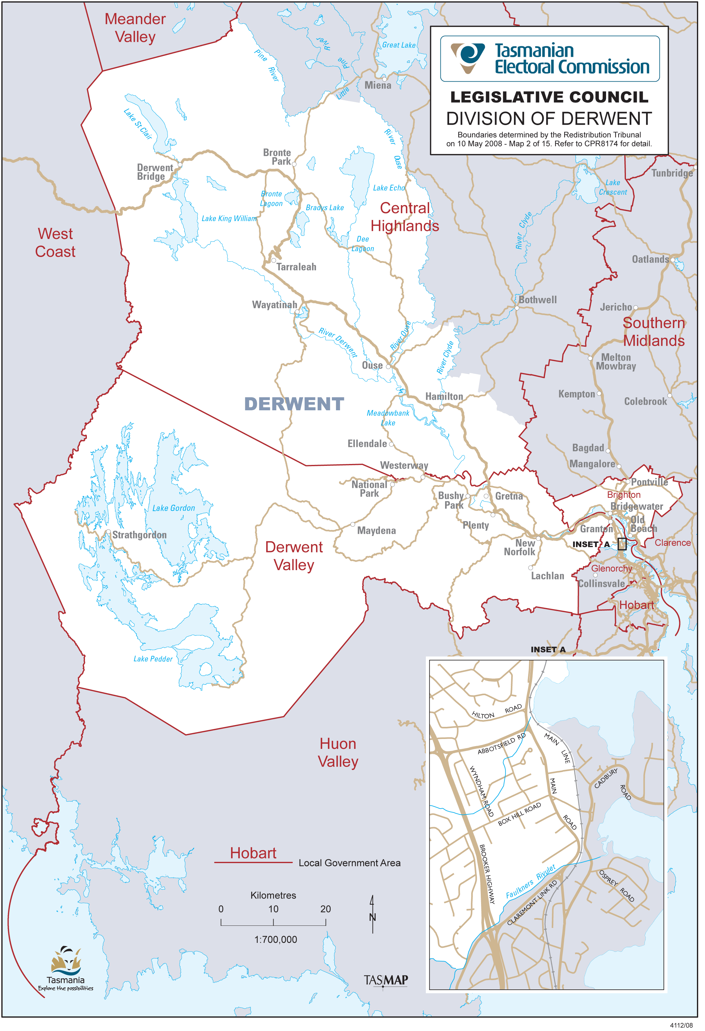
Derwent
takes in Derwent Valley municipal area, Brighton municipal area, part of Glenorchy City municipal area north of Faulkners Rivulet and west of the main railway line including Granton, Austins Ferry and parts of Claremont, part of Central Highlands municipal area south-west of Pine and Ouse Rivers including Derwent Bridge, Bronte Park, Tarraleah, Ouse and Hamilton.
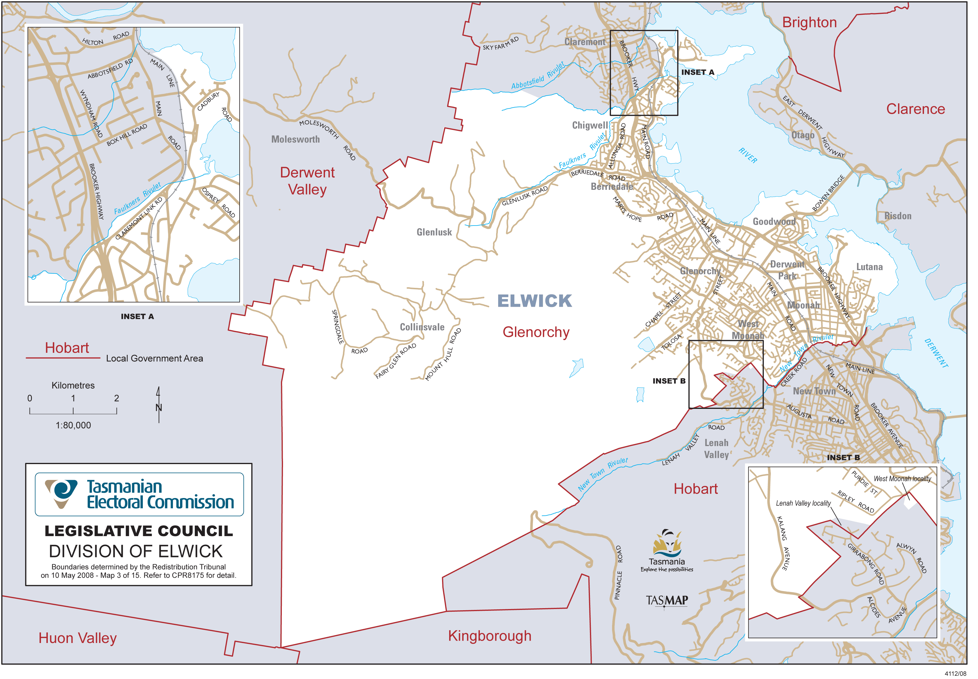
Elwick
takes in all of the Glenorchy City municipal area south of Faulkners Rivulet (in Claremont) and includes Cadbury Point east of the main railway line. Elwick includes the localities of: Chigwell, Berriedale, Collinsvale, Rosetta, Montrose, Goodwood, Glenorchy, Derwent Park, Moonah, West Moonah, and Lutana.
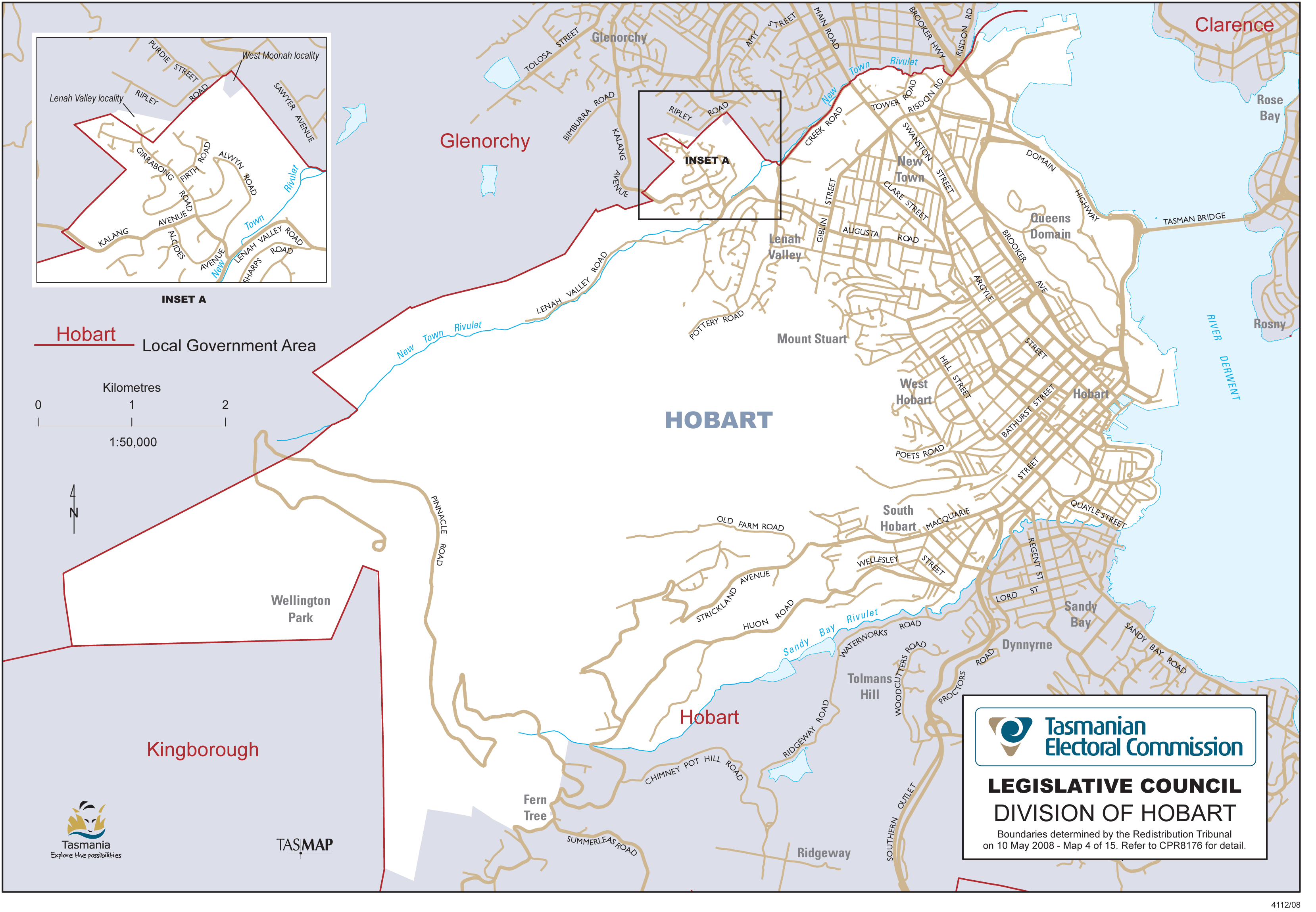
Hobart
division takes in the central Hobart metropolitan area north of the Sandy Bay Rivulet, including Lenah Valley, New Town, Mount Stuart, North Hobart, Glebe, West Hobart, Hobart, South Hobart and Battery Point.
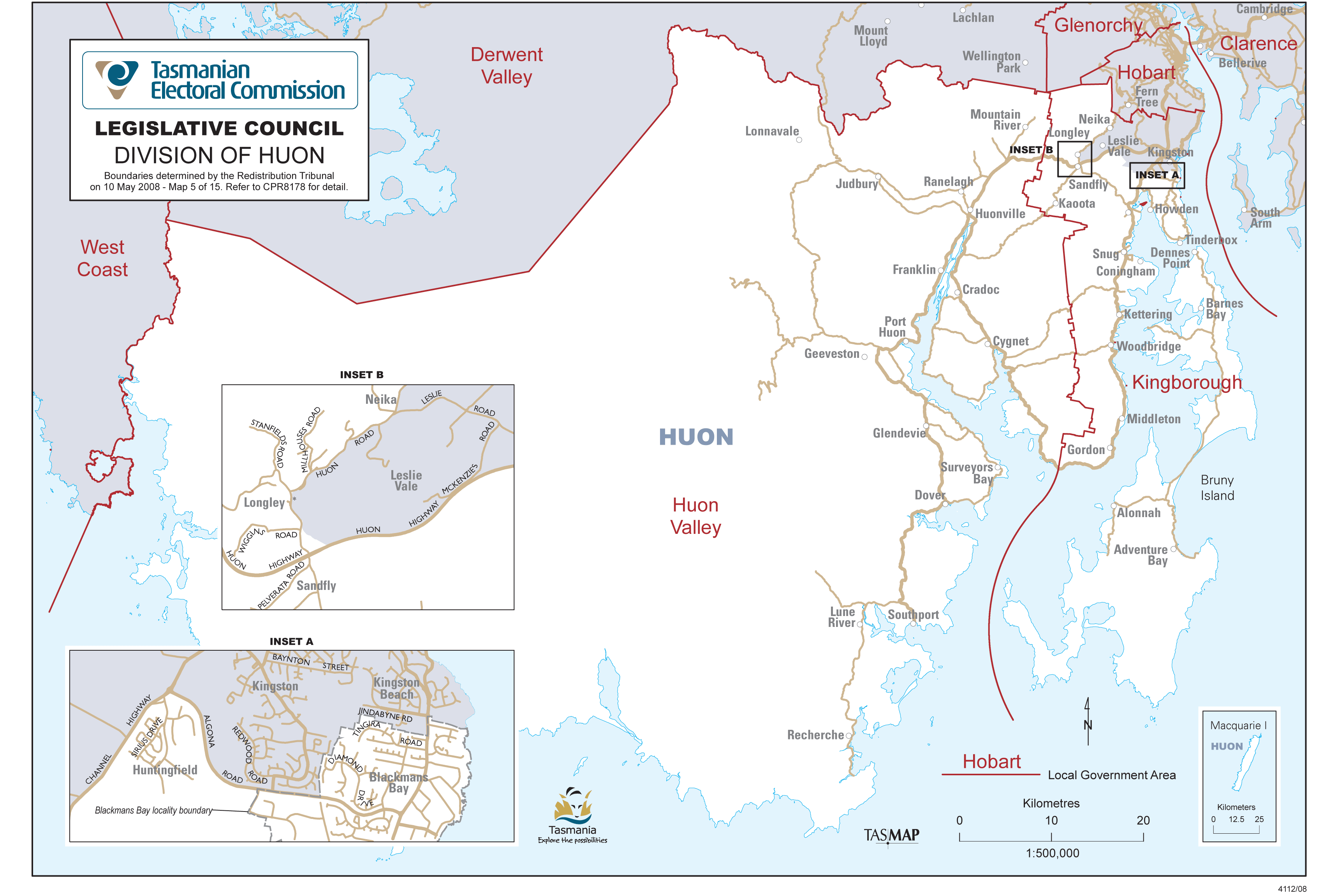
Huon
is a southern division that takes in Huonville, Cygnet, Franklin, Dover, Southport and Port Huon as well as Blackmans Bay and parts of Kingston. Bruny Island is also included in the division.
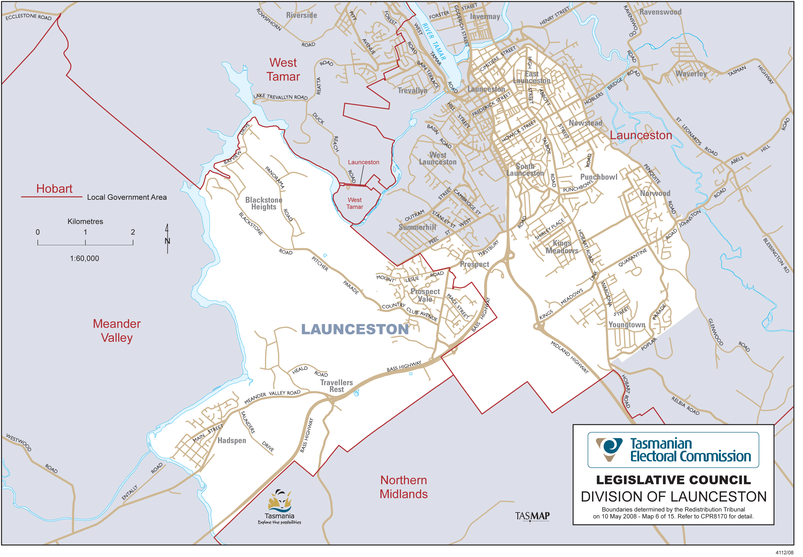
Launceston
takes in central and southern parts of Launceston City municipal area, including Youngtown, Punchbowl and Kings Meadows, and most of South Launceston, East Launceston, Newstead, Norwood and Prospect. It also includes Prospect Vale, Blackstone Heights, Travellers Rest and Hadspen from the Meander Valley municipal area.

Mersey
includes Devonport City municipal area, the region of Central Coast municipal area east of Claytons Rivulet and Little Claytons Rivulet including: Turners Beach, Leith, Forth and Kindred; the western region of Latrobe municipal area including: the Latrobe township, Tarleton and parts of Wesley Vale and Moriarty.
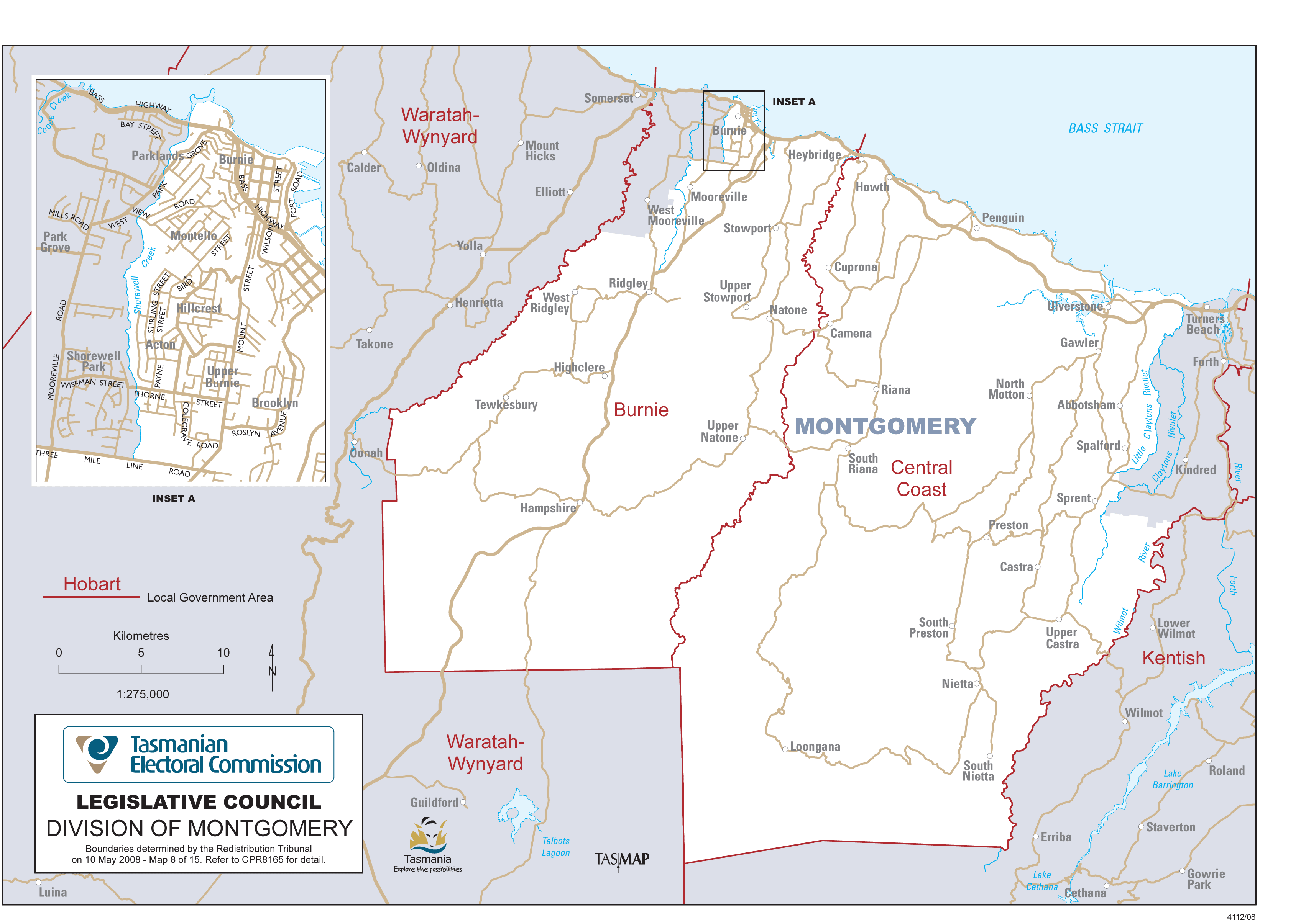
Montgomery
is a north western division extending from Burnie to Ulverstone, although it does not include that part of Burnie west of Shorewell Creek. Montgomery includes most of the hinterland of Burnie City and Central Coast municipal areas, but not Turners Beach, Forth or Kindred.
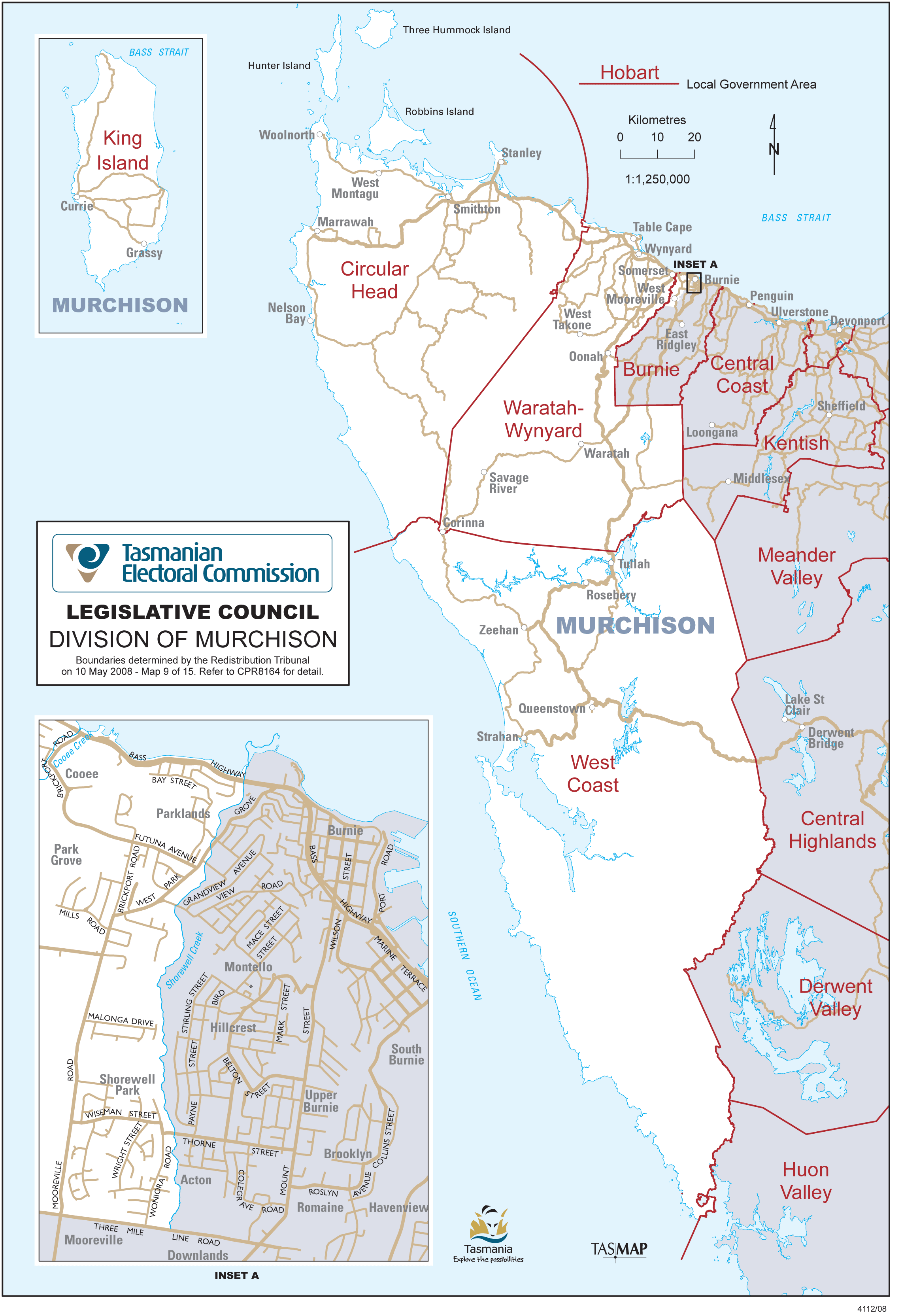
Murchison
takes in the municipal areas of Circular Head, King Island, Waratah-Wynyard and West Coast. It also includes part of the Burnie City municipal area lying generally west of Shorewell Creek.

Nelson
takes in Sandy Bay, Dynnyrne, Tolmans Hill, Mount Nelson, Fern Tree, Ridgeway, Taroona, Bonnet Hill, Kingston and Kingston Beach, along with parts of Leslie Vale, Neika and Longley.
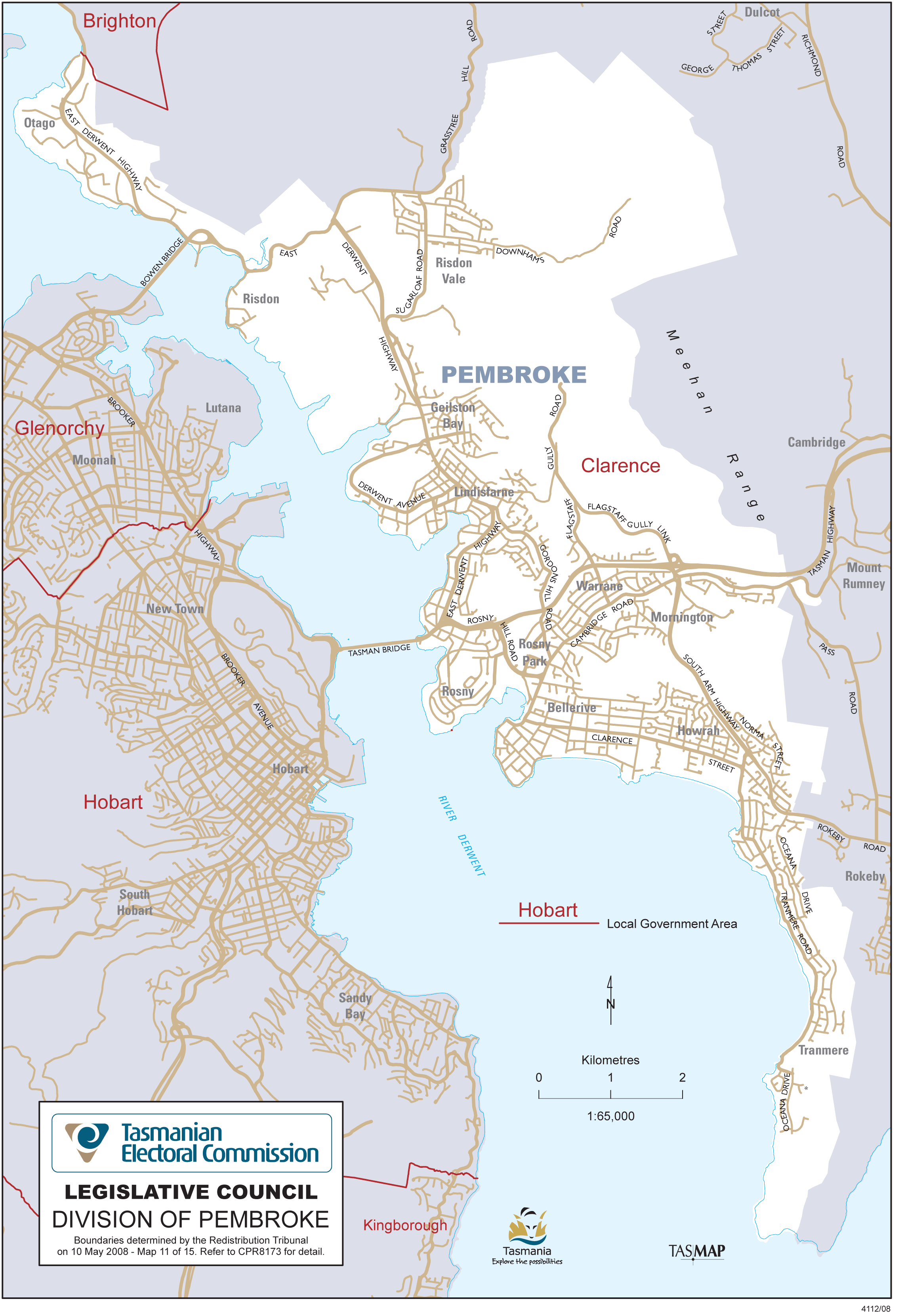
Pembroke
encompasses that part of the Clarence City municipal area lying west of the Meehan Range and includes Otago, Risdon Vale, Geilston Bay, Lindisfarne, Rose Bay, Rosny, Bellerive, Warrane, Mornington, Howrah and Tranmere. It does not include the area known as Howrah Gardens.

Rosevears
is a northern division that takes in Greens Beach, Beauty Point, Beaconsfield, Exeter, Legana and Rosevears as well as part of the City of Launceston, including Riverside, Trevallyn, West Launceston and Summerhill.
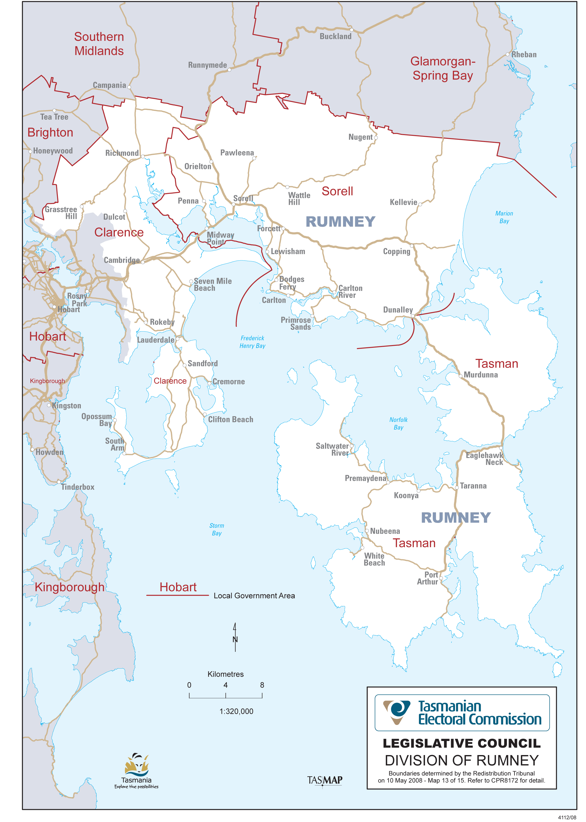
Rumney
includes the municipal areas of Sorell and Tasman, as well as that part of the Clarence City municipal area lying generally east of the Meehan range.
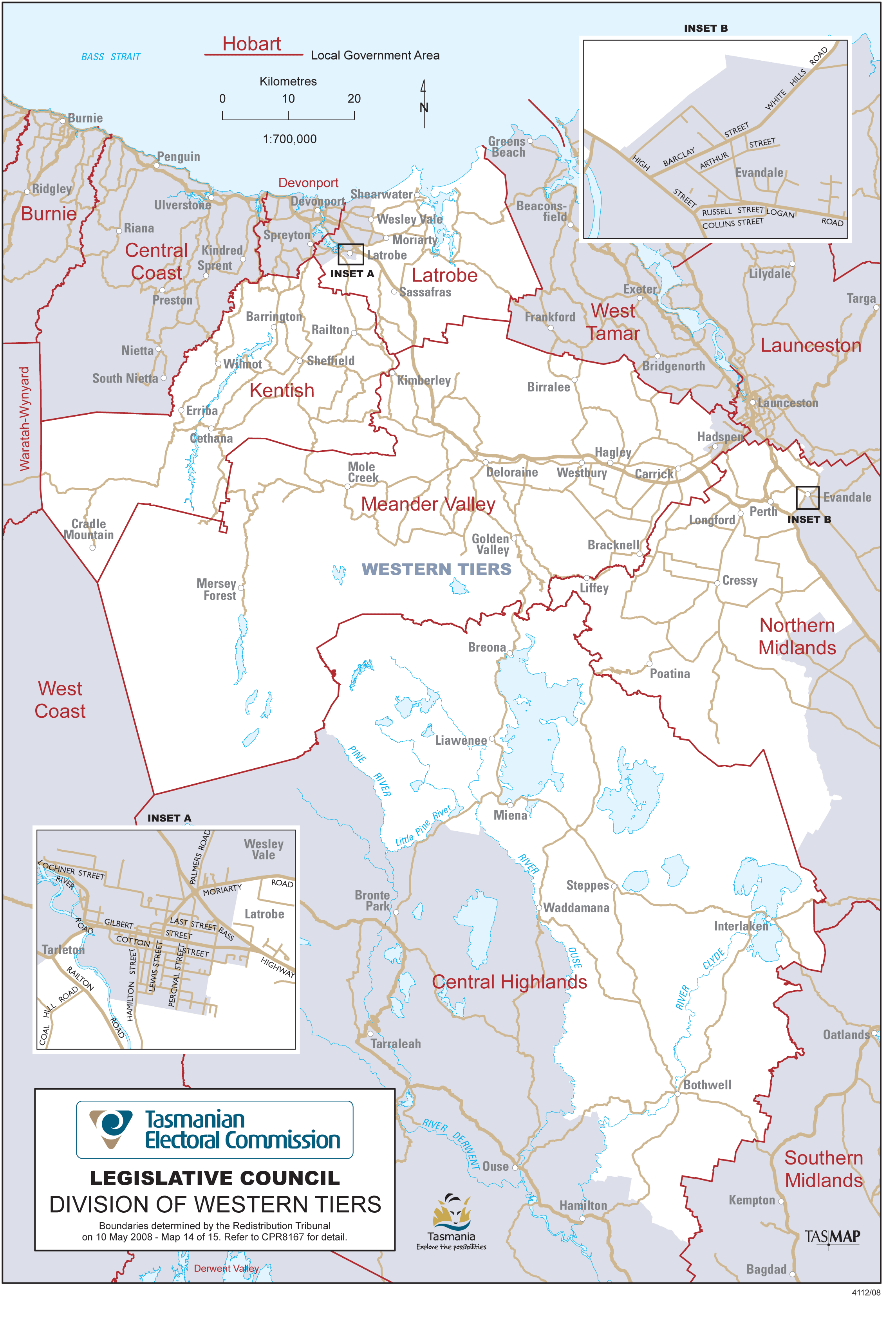
Western Tiers
takes in the Kentish municipal area, outlying parts of the Latrobe municipal area, the rural part of the Meander Valley municipal area west of the South Esk River, the western part of the Northern Midlands municipal area including Perth, Longford, Cressy and Poatina, and the northern part of Central Highlands municipal area including Bothwell, Waddamana, and the Great Lake
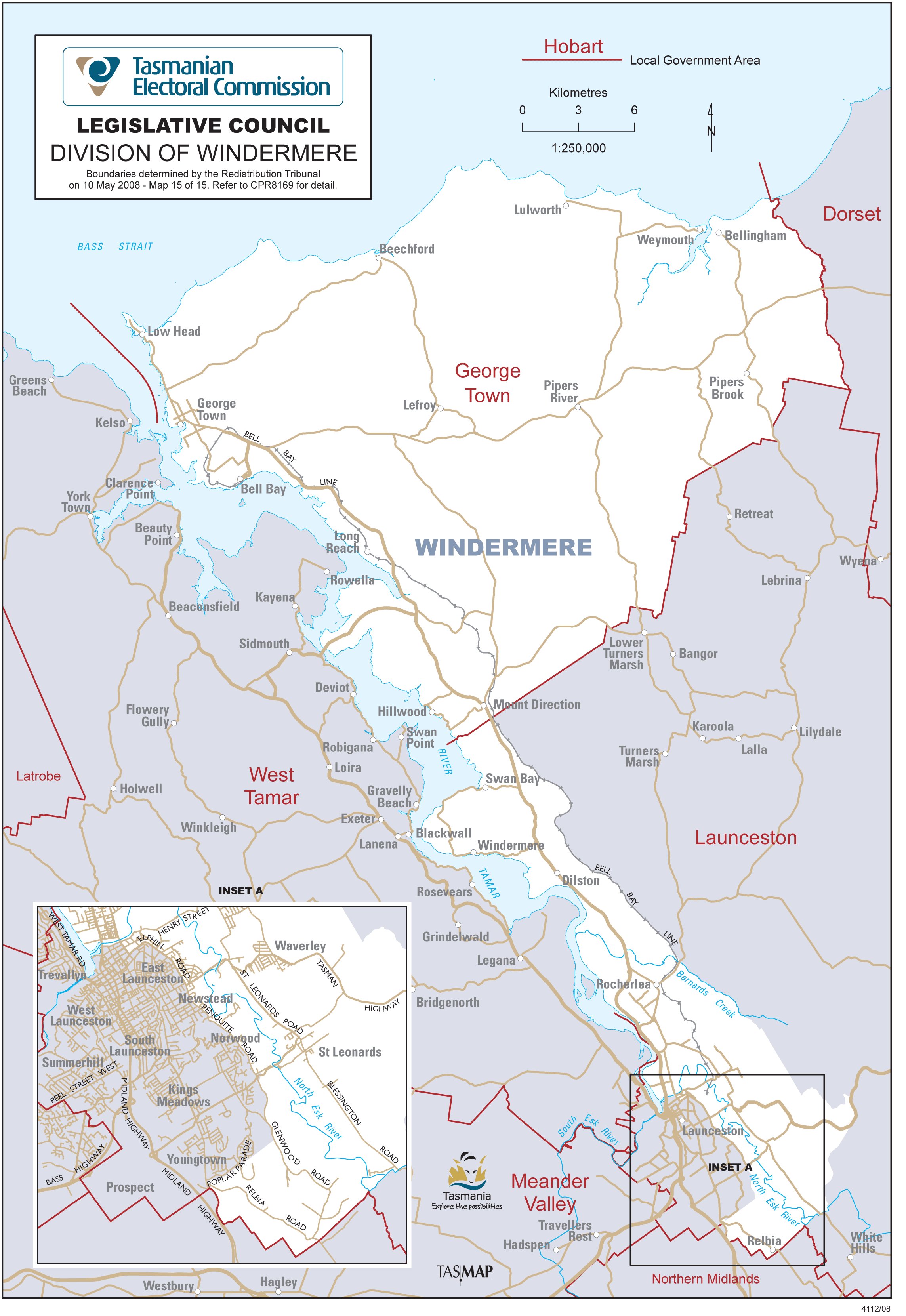
Windermere
includes George Town municipal area, East Tamar region from Swan Bay to Rocherlea, North Launceston suburbs from Mayfield to Invermay, Launceston suburbs east of Elphin Rd and Penquite Rd including: Ravenswood, Waverley, and St Leonards; parts of East Launceston, Newstead and Norwood.
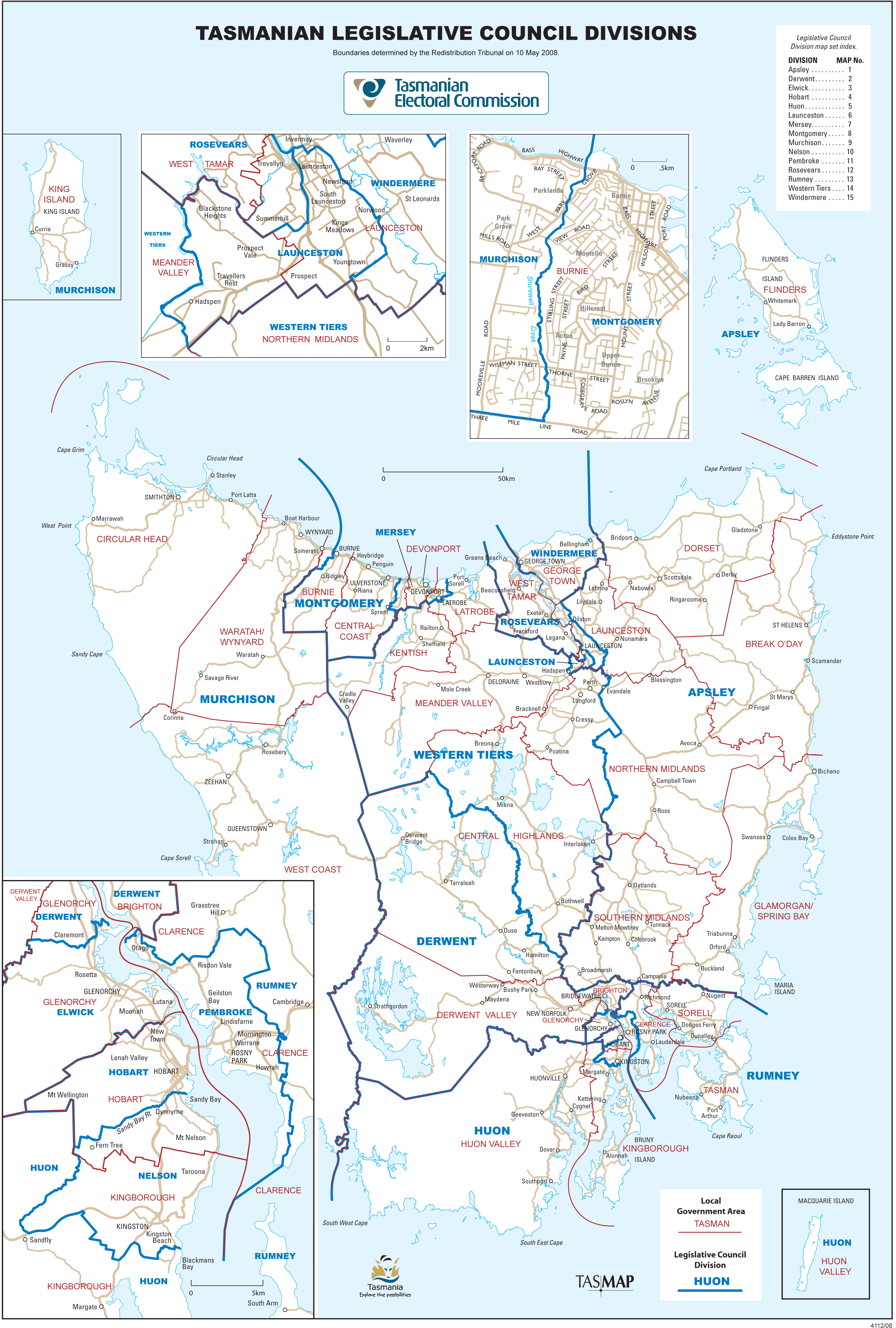
Whole of state map
Here is a little history behind the names of the current Legislative Council divisions.
Click on the division name to read more.
Apsley
Apsley takes its name from the Apsley River, mid-way along the East Coast, in the middle of the large division. The division covers most of eastern Tasmania, from Flinders Island in the north to Maria Island in the south.
The Apsley River rises on Mount Punter, north-east of Bicheno, and flows through the Douglas–Apsley National Park southwards to Moulting Lagoon and Great Oyster Bay. The park was created in 1990 to protect the last large, relatively undisturbed stands of dry eucalypts in the State.
The Apsley River was named by William Lyne, a surveyor from Coombend near Colesbourne in Gloucestershire. He had arrived in Van Diemen's Land in 1826 on his way to New South Wales. He carried a letter of introduction to Governor King of NSW from Lyne's friend and neighbour Lord Apsley, the Earl of Bathurst, who was the British Secretary for War and the Colonies. Lord Apsley had advised Lyne to settle in NSW rather than Van Diemen's Land because the latter had a major problem with bushrangers and restless natives!
Lyne and his family disembarked in Hobart, liked what they saw and offered Apsley's letter of introduction to Governor Arthur instead. Arthur was miffed that Apsley had said NSW was "safer soil" than Van Diemen's Land but granted Lyne 1500 acres (600 hectares) on the East Coast. Lyne was so delighted with his holding he called it Apsley and named the river that ran through it Apsley as well.
In about 1833 John Lyne, William's son, was granted 640 acres (256 hectares) adjoining his father's property. He called it Apslawn.
Derwent
The Derwent begins its 182 kilometre journey at Lake St Clair high in Tasmania's World Heritage wilderness region. It passes through mountain gorges, farmlands and hopfields, Hobart, its suburbs and port, and on to its mouth where it meets the Southern Ocean at the Iron Pot.
The Derwent River, from which the division takes its name, is a major geographical feature of central and southern Tasmania.
On the way, the waters of the Derwent have turned turbines to generate electricity, provided drinking, irrigation and industrial water for farms, towns and cities, opened up sea lanes to the world and given Tasmanian residents and visitors a major recreational asset. In earlier times it was a favourite playground of southern right whales—so much so that the noise of their mating kept residents awake.
The first european sighting of the Derwent was probably by the French explorer La Perouse in 1788.
The Derwent was named by the explorer Sir John Hayes, who led a private expedition to southern Van Diemen's Land between April and June 1793 with two ships, the Duke of Clarence and the Duchess of Bengal.
He explored the lower reaches of the Derwent, probably as far upstream as New Norfolk, naming features that still retain the names he gave them, including Risdon Cove and Cornelian Bay.
Unknown to him at the time, Hayes was not the first european discoverer of the Derwent. Hayes was later to learn that the French explorer Admiral Bruni D'Entrecasteaux had discovered the river shortly before him, naming it the Riviere du Nord (because it flowed from the north).
Hayes named the Derwent after two geographical features in the Lake District in his native Cumberland in England—Derwentwater and the Derwent River, which passes through the lake.
Elwick
The name of the division of Elwick has been synonymous with Glenorchy in Hobart's northern suburbs for more than 150 years. Today it is reflected in one of Australia's premier racecourses, Elwick Road and Elwick Bay on the Derwent River.
In the early days Glenorchy (originally known as O'Briens Bridge) was a largely rural community. In the 1840s two-thirds of its several hundred residents were engaged in farming.
Other residents living closer to what is now central Hobart commuted to work. One of these was chemist John Norton Wilkinson, who owned a property named Elwick.
Wilkinson arrived in Tasmania about 1830. It is probable that he named his land after what may have been his birthplace in England (there is a small village of Elwick—derived from the name Ella and the suffix wick for town—in County Durham).
His holding covered what is now Elwick Racecourse and continued further on to the Derwent River.
In 1874 the Tasmanian Racing Club (formed 1870) acquired the property as a racecourse and the homestead at Elwick was demolished. The first races were held in February 1875. A half holiday was declared; 5 000 people attended, many of them arriving on the newly-introduced railway service. The Governor Sir Frederick Wells was among the spectators.
Wilkinson lived for another 11 years and his obituary in the Tasmanian newspaper in November 1885 noted that he was " . . . a colonist of over half a century's standing in Tasmania and the oldest chemist and druggist in the colony. It continued: "He was respected by all who knew him and by frugality obtained a competence for life".
Glenorchy, and the surrounding area, is now very much a part of Hobart's urban landscape, but its rural past lives on through the name Elwick.
Hobart
The Division of Hobart is named after Tasmania’s capital city and the second oldest city in Australia. It was settled at present day Risdon Cove on the Eastern Shore in 1803 before it moved across the Derwent River to Sullivan’s Cove the following year.
The City of Hobart takes its name from Lord Robert Hobart, the British Secretary of State for the Colonies.
The Division includes New Town, Lenah Valley, Mt Stuart, West Hobart and South Hobart with the Hobart central business district being the focus.
The border on the northern side is the same as the border between the local government areas of Glenorchy City Council and Hobart City Council with minor exceptions while the southern boundary is the Sandy Bay Rivulet. The eastern boundary is the Derwent River while in the west the boundary is Mount Wellington.
The name Hobart has been used as a Division name previously from the 1850s until 1999, when most of Hobart was renamed Wellington. It was Hobart Town between 1851 and 1856, when a redistribution occurred and the division became the Division of Hobart. Hobart Town remained the name of the settlement until 1875 despite it being declared a city in 1842.
It was decided to return to the name of Hobart because of the significance of the city in Tasmania and Australia’s history and also because the name has been used for the division for all but its nine years as Wellington and the brief period at the beginning when it was known as Hobart Town. It was also a factor that Mount Wellington is a feature to a number of the southern divisions and that the name of Wellington did not adequately distinguish the division.
The time when the division was known as Wellington also meant that Hobart was the only state capital not to be used as the name for a parliamentary seat.
Huon
The Huon River, Huon Valley, Huonville, Huon pine, Glen Huon, Port Huon—the list, which also includes the name of the electoral division, continues. Huon Kermandec certainly left his mark on the region in southern Tasmania that bears his name.
The region's major feature, the Huon River, rises as a small creek with sources on Mount Wedge and Mount Bowes, deep in Tasmania’s South-West wilderness. On its 170-kilometres journey the Huon traverses button grass plains, speeds swiftly through the Southern Forests, glides through rich agricultural land and orchards, flows past old world villages and, finally, enters the D’Entrecasteaux Channel, one of Australia’s finest waterways. It reaches the sea as one of Australia’s major rivers. The Huon River is the life-force of the Huon Valley.
The Huon region was first charted by the French explorers Admiral Bruni D'Entrecasteaux and his second-in-charge Commander Huon Kermandec in 1792. Bruny Island, the D'Entrecasteaux Channel, the Huon and Kermandie Rivers and districts bear their names, while Esperance and Recherche Bay are named after their ships.
D'Entrecasteaux and Kermandec were confronted by a shoreline comprising vast, dense forest extending inland to the mountain ranges. Those forests were later to provide one of Tasmania's most prized timbers, Huon pine.
The first permanent settlement in the Huon was in 1835. Settlement increased as timber getters extended their camps and activities, seeking, in particular, blackwood for casks and barrels, and the valuable Huon pine.
In the following years development has continued, with the Huon Valley producing much of Tasmania's timber, fruit, agriculture, and more recently, aquaculture, and a growing tourism industry.
The name Huon continues an original Legislative Council electorate name dating back to 1851.
Launceston
The Division of Launceston is named after Tasmania’s 2nd oldest city, which is also the third oldest city in Australia.
The Europeans settled Launceston in 1805 after the settlement was moved along the Tamar River from the original settlement at George Town, which was settled in 1804.
Launceston is named after Launceston in Cornwall, England.
The division of Launceston’s boundaries extend to part of Hadspen, Blackstone Heights Kings Meadows, Youngtown and Norwood with the main focus of the division being the central business district.
Launceston has been used as a division name previously with the change to its former name of Paterson only occurring in 1999.
It was decided to return to the name of Launceston because of the significance of the city in Tasmania and Australia’s history and also because the name has been used for the division for all but its nine years as Paterson.
Another reason for the use of Launceston was that Paterson did not connote a well-known geographical feature.
As well as being the third oldest city in Australia, Launceston is also the site of the first anaesthetic use in the Southern Hemisphere and the first Australian city to have both underground sewers and hydro-electricity.
Mersey
The Mersey River, from which the division takes it name, is often described as the 'gateway' to Tasmania. It offers thousands of visitors a year their first experience of Tasmania as they disembark from the Spirit of Tasmania at Devonport.
The name also encompasses the prominent Mersey Bluff and several streets in Devonport.
The Mersey River rises high on the Central Plateau traversing 146 kilometres before reaching the sea at Devonport.
The first European sighting of the Mersey area was by Bass and Flinders during their circumnavigation of Tasmania in 1798. They named only prominent features, which did not include the Mersey.
In 1804 a settlement was established on the Tamar River (Port Dalrymple) and during exploration from that settlement four rivers were named, the second of which, named Second Western River, would later become the Mersey.
In 1823 Lieutenant-Governor Sorell ordered exploration of the land west of Launceston (the area now known as the North-West Coast), with several expeditions passing through the area covered by the Mersey division. One of those early explorers, Captain Charles Hardwicke, who sailed along the coast in 1823, described the area as: "... mountainous, extremely barren and totally unfit for habitation".
In 1824 the Van Diemen's Land Company was formed in London. The company received a royal charter to open up grazing land, principally for merino sheep, in the north-west. Under the direction of Edward Curr, the first manager, the company sought out suitable land before establishing its headquarters at Highfield, Stanley.
The VDL Company continued its investigation of the area. In 1826 Curr or the surveyor William Goldie named the river the Mersey, following the then custom of copying English names. The Mersey flows through Liverpool in England.
If only Charles Hardwicke could see the region today that he judged so harshly all those years ago.
Montgomery
The name Montgomery has strong links with Tasmania.
Field Marshall Viscount Bernard Montgomery received part of his education here as the son of Anglican Bishop, Sir Henry Montgomery. The young Bernard was educated at Hobart's St Michael's Collegiate School, which still has a House named Montgomery, after the Bishop.
An early county of Van Diemen's Land was also named Montgomery, but most likely after the Welsh county, as was the early custom.
But the division is named after none of these. It is named after Mount Montgomery in the Dial Range behind Penguin. It, in turn, is thought to derive its name from a young New Zealand surveyor, Alexander Montgomery, who came to Tasmania in 1889 to become Geological Surveyor and who later became Inspector of Mines.
Montgomery was described by a referee for the Tasmanian job as "a brilliant student, strong, active and reliable". Among his work is a study on the discovery of iron ore at Penguin.
There is also a reference in some records to the mountain being named after "a Mr Montgomery" in England who, sight unseen, had selected a 320-acre (128 hectare) holding in Tasmania that included the mountain but who later gave it away in disgust.
The mountain, part of the 300 hectare Mount Montgomery State Reserve, can be reached from Ironcliffe Road. At 471 metres, the summit provides a stunning vista of northern Tasmania—Table Cape, St Valentine's Peak, Black Bluff, Mount Roland, Mount Barrow, Ben Lomond and the Asbestos Range.
Murchison
Mount Murchison, which gives the division its name, is the dominant feature of the northern end of the West Coast Range, a 'backbone' extending 55 kilometres southwards to Mount Darwin.
At 1275 metres it is a conspicuous landmark in the region around Rosebery.
Mount Murchison was named by Charles Gould in February 1860 on his first gold-seeking expedition to the West Coast. Sir Roderick Murchison was a pioneer geologist and Director of the Geological Survey of Great Britain, in which Gould had been engaged.
Murchison and others had recommended Gould for membership of the Geological Society of London and Murchison, in response to the Tasmanian Government's inquiry, had recommended Gould for the position of Geological Surveyor of Tasmania. Gould had similarly named other mountains of the West Coast Range after prominent natural scientists of the time: Sedgwick, Lyell, Owen, Huxley, Jukes, Darwin.
The name continues with the Murchison River, a tributary of the Pieman, rising deep in the heart of the Cradle Mountain–Lake St Clair National Park. The river was named in honour of Murchison in April 1859 by the leader of another gold expedition, W.A. Tully. The Murchison River was dammed for hydro-electric power generation as part of the Pieman power development.
The Murchison Highway, built in the 1960s, provided the first direct road link between the West and North-West Coasts.
Earlier, a Dubbs locomotive, the Murchison, saw service on the Emu Bay Railway line between Burnie and the West Coast from 1901 to 1963. The locomotive is now at the West Coast Pioneers Memorial Museum at Zeehan.
Nelson
The division of Nelson takes its name from the 340-metre high backdrop to the Hobart suburbs of Sandy Bay, Taroona and Kingston. Mount Nelson is a popular lookout, with sweeping panoramic views of the Derwent estuary, Storm Bay, the city and suburbs and out across the hills of the Eastern Shore.
It has long been recognised as a vantage point and in the early years of settlement was the site for a signal station, which told the people of Hobart that ships were entering the Derwent. The pole from which the signal flags were flown still exists. Mount Nelson—reached by a somewhat tortuous road, noted for its seven bends—is now largely suburban.
Mount Nelson was not, as might be expected, named after the British admiral of Trafalgar fame, Lord Horatio Nelson. It was named by Governor Macquarie in 1811 for the ship Lady Nelson because of the prominent role it had played in early Australian exploration and settlement. The ship, in turn, was named after Lady Fanny Nelson, wife of Horatio. Fanny (Mrs Nisbet) was a widow, whom Nelson met on the island of Nevis, in St Kitts–Nevis in the West Indies, while staying with her uncle, the President of the Council of Nevis. Of Nelson's marriage partner, a fellow officer observed: "Captain Nelson has married a complexion combined with a remarkable absence of intellectual endowment".
The Lady Nelson sailed from England to the colony of New South Wales in 1800 and for the next three years explored the Australian coast. In 1803, after a false start, she brought the first group of settlers to Van Diemen's Land, as Tasmania was then known. The group arrived at Risdon Cove on September 7. The following year the Lady Nelson was used to survey Port Dalrymple (the lower reaches of the Tamar River), where a settlement was established at York Town (now marked only by a monument at West Arm), subsequently relocated upriver to Launceston. A further task was to relocate the Risdon Cove settlement to Sullivans Cove, close to the centre of present-day Hobart.
The Lady Nelson lives on in the form of a full-scale replica, built as Tasmania's sail training ship.
Pembroke
Pembroke has been part of Tasmania and Van Diemen's Land since 1836, when the county of that name was first gazetted. The original electorate took its name from the county and covered much the same area of south-east Tasmania.
Under Governor Arthur, Van Diemen's Land was divided into counties, each of 1600 square miles (4144 square kilometres), each of which was subdivided into "hundreds" of 100 square miles (259 square kilometres), and each "hundred" divided into four 25 square mile (65 square kilometres) parishes.
Surveyors and land commissioners working under Surveyor-General George Frankland had a strong say in the naming of the counties, many taking them from British places with which they had links.
Hence, Pembroke the Tasmanian county and Legislative Council division take their name from the Welsh county of Pembrokeshire, recently re-created by the British Government after being absorbed into the larger county of Dyfed in 1972.
Probably the best-known feature of Pembrokeshire is Pembroke Castle, built by Roger de Montgomery in 1093 on Milford Haven as a strategic fortress in the Norman conquest of England. It is said to be the birthplace of the first Tudor king, Henry VII in 1457.
The current division of Pembroke covers most of the urban area of Hobart's Eastern Shore from Risdon Vale in the north to Droughty Point in the south.
Rosevears
The division of Rosevears takes its name from the village of Rosevears, on the banks of the West Tamar, in the heart of the West Tamar-based division.
William Henry Rosevear arrived in Tasmania from the colony at Swan River (Perth, Western Australia) with his wife and children in 1829. He had spent most of his working life as a farmer in Cornwall, England, and, in view of his experience on the land, was granted 640 acres (256 hectares) in the West Tamar. He was granted a further 430 acres (172 hectares) 10 years later in 1839. The land was used for orcharding and other agricultural pursuits.
Rosevear was also a publican, holding the licence of the Half Way House between 1833 and 1834, and was listed as the licensee of the Rose Inn in 1835 and again between 1848 and 1851. The Rose Inn was first licensed in 1831 and trades today as the Rosevear Waterfront Tavern. Sections of the interior retain the original brickwork.
Rosevear described himself in the census of 1848 as being in the "Landed Proprietors, Merchants, Bankers and Professional persons class". He died in 1860, aged 73.
Rosevears was the site of early shipbuilding. The area and the shipyards were also known as Battery Point and Cimitiere's Point (taking its name from Colonel Gilbert Cimitiere, who was Commandant of Port Dalrymple between 1818 and 1822). Among the shipbuilders were the Plummer family. Sea captain George Plummer arrived in Tasmania in the late 1820s. The Plummers' shipyard built the Rebecca, in which John Batman sailed to Port Phillip in 1835, which resulted in the founding of Melbourne.
Rumney
The division is named after Mount Rumney on Hobart's eastern outskirts. The mountain overlooks much of the division.
Mount Rumney (378 metres) is part of the Meehan Range, the dominant geographical feature of Hobart's Eastern Shore. The expansive views eastwards to Frederick Henry Bay and beyond, southwards to South Arm and Storm Bay and south-east to the Tasman Peninsula—the areas which comprise the Rumney division—have attracted residential development to the mountain.
The mountain and Rumney Creek are both named after William Rumney, who was a pound keeper and constable in the Rokeby area in the 1820s. He also owned land at Baden, near Oatlands. Baden was originally known as Rumney's Hut.
By 1828 Rumney was the major landowner in the area then known as Clarence Plains. That area had been named by Sir John Hayes in 1793 after his ship the Duke of Clarence, in which he explored much of southern Tasmania. The former Clarence Plains is modern-day Rokeby.
Rumney's holding ran from Ralphs Bay to Mount Rumney and through to Seven Mile Beach. He built Acton House on the eastern side of Mount Rumney some time before 1842.
Western Tiers
The Division of Western Tiers centres on the mountain range officially known as the Great Western Tiers. (Koorparoona Niara is said to be the aboriginal name for the region).
The Western Tiers rise 1420m above sea level and the area includes Lake Rowallan (a Legislative Council Division was named Rowallan between 1999 and 2008). Other geographical features include Liffey Falls, Marakoopa Cave, King Solomon’s Cave and Lake McKenzie.
Towns in the division include Bracknell, Bothwell Chudleigh, Cressy, Deloraine, Hadspen, Longford, Meander, Mole Creek, Perth Port Sorell, Sheffield, Railton and Westbury.
The name Western Tiers was used in preference to Great Western Tiers for simplicity. It was also taken into account that the Western Tiers can be seen by people living in 4 out of 5 local government areas in the Division and because it forms part of the Central Highlands, which is the 5th municipality in the division.
Windermere
Windermere is the East Tamar division that takes its name from a picturesque village on the Tamar River about 17 kilometres north of Launceston.
The village, in turn, takes its name from the largest lake in the Lake District in England (Vinand's Lake, from a Swedish personal name, a rarity in English place-names, followed by the old English mere for lake). The name was recorded as Winendermer in a text of about 1170.
Windermere, Tasmania, was named by an early settler, Dr Matthias Gaunt, who arrived in Van Diemen's Land with his family in 1831. Gaunt was granted 2 500 acres (1 000 hectares) of land on the East Tamar.
He chose not to practise medicine in the colony; instead he planted a vineyard and converted a sawmill to a flour mill. The mill was successful and its flour won a first place at the Great Exhibition in London in 1851. Gaunt's success as a miller prompted a visit from Governor Sir John Franklin in 1842, who suffered the indignity of being covered in flour let loose by two of Gaunt's sons from a loft above.
Gaunt is said to have promised his wife Eliza before leaving England that, if there were no church where they settled in the colony, he would build one and name it St Matthias. The result, completed in 1843, is the charming white stone church that overlooks the Tamar at Windermere. Gaunt's gravestone is prominent in the cemetery, along with those of other early East Tamar pioneers. For many years, parishioners living along the Tamar used boats to travel to services at St Matthias Church.
References
We would like to thank and acknowledge the following: